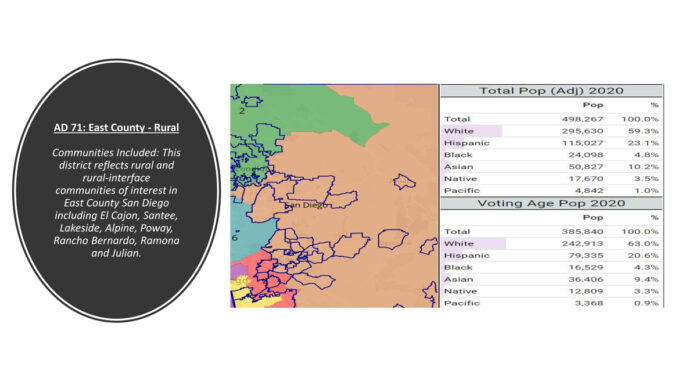
El Cajon City Council unanimously voted for a resolution opposing the visualization maps of San Diego County’s draft district maps for State Assembly, State Senate, and Congress, contesting that the proposed district lines are “detrimental to the city of El Cajon” at a special City Council meeting Tuesday.
In addition, the Council endorsed draft maps endorsed by the Lakeside and Escondido chambers of commerce.
Lakeside Chamber of Commerce President/CEO Kathy Kassel said that the Lakeside and Escondido chambers reviewed and endorsed the proposed draft maps as they were in line with the redistricting changes that they support the greater good of their respective communities.
The California Citizens Redistricting Commission released current proposed maps for congressional, state senate and state assembly district boundaries on Nov. 12, three days ahead of the Nov. 15 deadline. Between Nov. 15 and Dec. 1, the CRC will accept public comments. Final maps will be published no later than Dec. 23 with final maps adopted on Jan. 22, 2022.
At the Nov. 9 City Council meeting, City Manager Graham Mitchell said the proposed map would have El Cajon’s in an assembly district with La Mesa, Spring Valley, Lemon Grove, and a portion of east San Diego.
“It would actually separate us from Rancho San Diego, and if you consider the community interest of Middle Eastern, it really divides that community of interest,” he said. “It also separates this portion of East County from Lakeside, Santee, Ramona, and Alpine.”
Graham said this would affect Santee, and Lakeside would include areas around Miramar, down the major corridor of I-805 and the I-15 and would include areas of Tierra Santa, San Carlos, all the way to 32nd Street in downtown San Diego, Balboa Park, Hillcrest, North Park.
“If you really think about East County as a community of interest, represented by one high school district, two water districts, this would completely split up that community of interest, and would put us with communities that historically we do not have a relationship with,” said Graham.
Graham said that the maps endorsed by the Lakeside and Escondido chambers of commerce is an effort to get communities behind these maps that would be a true East County San Diego assembly district, which aligns more with the region’s historic nature. It separates El Cajon from La Mesa and Lemon Grove but keeps the rest of the area intact.
Graham said looking at the State Senate the CRC’s conceptual map has El Cajon separated from much of East County, having El Cajon continuing with the cities of Lemon Grove and La Mesa, a portion of San Diego and Poway. He said the endorsed map would separate it from Lemon Grove and La Mesa, but would include up to Escondido, parts of San Marcos and much of East County.
Graham said the congressional district map shows El Cajon, Lakeside, Rancho San Diego, La Mesa, Lemon Grove, follows down SR-125 connecting down to National City. Graham said the preferred map shows El Cajon with the similar communities including Alpine, Escondido, San Marcos, and Poway.
Graham said staff was looking for direction from City Council on the alternate maps better than the one the CRC proposed, time commitment to work with neighboring communities, utilize social media, encourage public comment, and arranging council members and staff to engage in public comment.
Council member Gary Kendricks said he much preferred the maps endorsed by the chambers because with communities of interest El Cajon does not have much in common with some of the coastal communities.
“The further west you go, the less East County you get,” he said. “We have a lot in common with Santee, Lakeside, Rancho San Diego. We are still a lot like Escondido when you look at the demographics. This is a relatively rural East County…I think the values of East County would be diluted.”
Council member Phil Ortiz said he liked the endorsed maps and that there were similarities in east and north county San Diego with respect to rural versus urban.
“I do not see the CRC map showing that as a community of interest,” he said. “Anyone that has lived in San Diego for any number of years knows East County is its own region…Another thing, I think that some tribal nations are divided in the committee maps presented breaking up that community of interest.”
Diaz said that not only should they be supporting the chambers’ endorsed maps, but also stating the regions communities of interest in word so if the CRC does not like the maps the city approves, it still understands the community of interests in the region that make up East County to take into consideration and supported creating a resolution to get on the record.
Council member Michelle Metschel said the East County region of San Diego County is a valid community of interest sharing historically agricultural roots as well as common values.
“The rural areas and the unincorporated areas of this region must be kept together and grouped with other similar communities,” she said. “This region includes but is not limited to the following communities: Alpine, Bonsall, Borrego, Campo, Potrero, Dulzura, Boulevard, Descanso, El Cajon, Julian, Santee, Lakeside, Poway, Ramona, Ranchita San Diego, Jacumba, and Santa Ysabel. You should also consider keeping the Kumeyaay tribes together.”
Council member Steve Goble said he supported the endorsed maps because there are many things that define East County such as its high school districts, elementary school districts, hospital district, community college district, wastewater, water districts.
“They are all East County,” he said. “We already have this personality of working together in East County and it would not make sense to break that up.”


